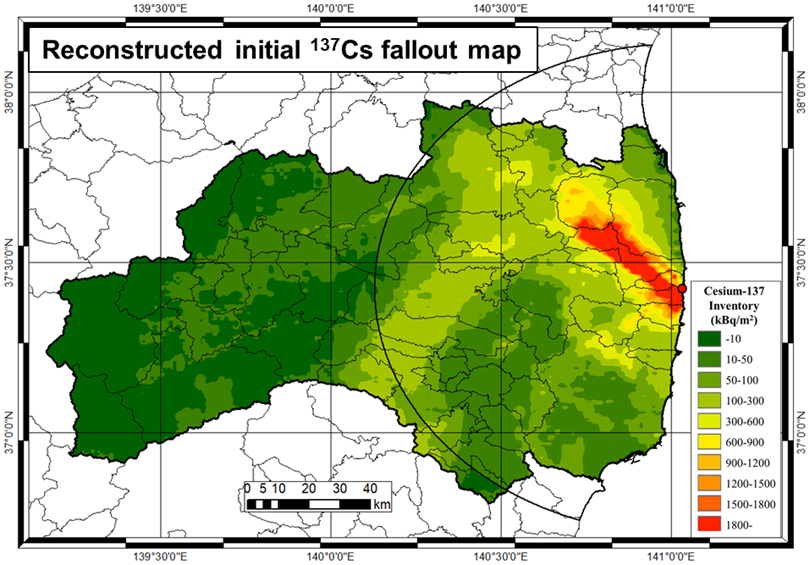
This database consists of the reconstructed initial fallout map of the Fukushima accident-derived radiocesium in Fukushima Prefecture and eastern part of Japan. The cesium-137 aerial deposition densities derived from the third, fifth and the prefecture airborne monitoring surveys were compared and adjusted for variation in the measured radioactivity associated with the influence of multiple factors on radioactive decay, including the half-life of radiocesium, natural weathering processes, variation in the calibration procedure used between the airborne monitoring surveys, and other undefined mechanisms. Finally, calibrated deposition densities for each land use type from the fifth airborne monitoring survey were used to complement the fallout map derived from the third airborne monitoring survey.
The reconstructed fallout map consists of a point dataset, containing deposition densities of radiocesium and the geographic coordinates (WGS84) of the median points of the quarter grid squares (250 m × 250 m mesh). It should be noted that the detection limit of 137Cs deposition density for the airborne monitoring surveys was set to below 5 kBq m2 to evaluate deposition densities in less contaminated areas, and a value of zero was assigned instead. The reference date of the combined fallout map is the same as that of the third airborne monitoring survey, July 2, 2011. The original dataset of the reconstructed fallout map is available online from the website of the Center for Research in Isotopes and Environmental Dynamics, University of Tsukuba.
| General Characteristics | |
|---|---|
| Parameters: | Mesh identification code, Latitude [in decimal degree, WGS1984], Longitude [in decimal degree, WGS1984], Reference date for Cs-137 inventory [yyyy/mm/dd], Cs-137 inventory [Bq/m2], Land use type [10=paddy field, 20=other farmland, 50=forest, 60=Wasteland, 70=buildings, 91=road, 92=railway, 100=other, 110=river and lake, 140=beach, 160=Golf, 0=unclassified] |
| Processing Level: | - |
| Temporal Resolution: | Specific point in time (July 2, 2011) |
| Start Date: | July 2, 2011 |
| Stop Date: | - |
| Observatory Location | |
|---|---|
| Observation Site: | Dataset A: Fukushima Prefecture Dataset B: Prefectures of Fukushima, Miyagi, Tochigi, Gunma, Ibaraki, Chiba, Saitama, Kanagawa, and Tokyo |
| Spatial Resolution: | Approx. 250-m interval |
| Latitude: | Dataset A:36°47'33.7"N(36.7927)~ 37°58'33.6"N(37.9760) [WGS1984] Dataset B:34°40'48.7"N(34.6802)~ 39°00'03.6"N(39.0010) [WGS1984] |
| Longitude: | Dataset A:139°10'01.9"E(139.1672)~ 141°02'20.8"E(141.0391) [WGS1984] Dataset B:138°23'54.2"E(138.3984)~ 141°40'24.2"E(141.6734) [WGS1984] |
| Elevation | - |
 Dataset A 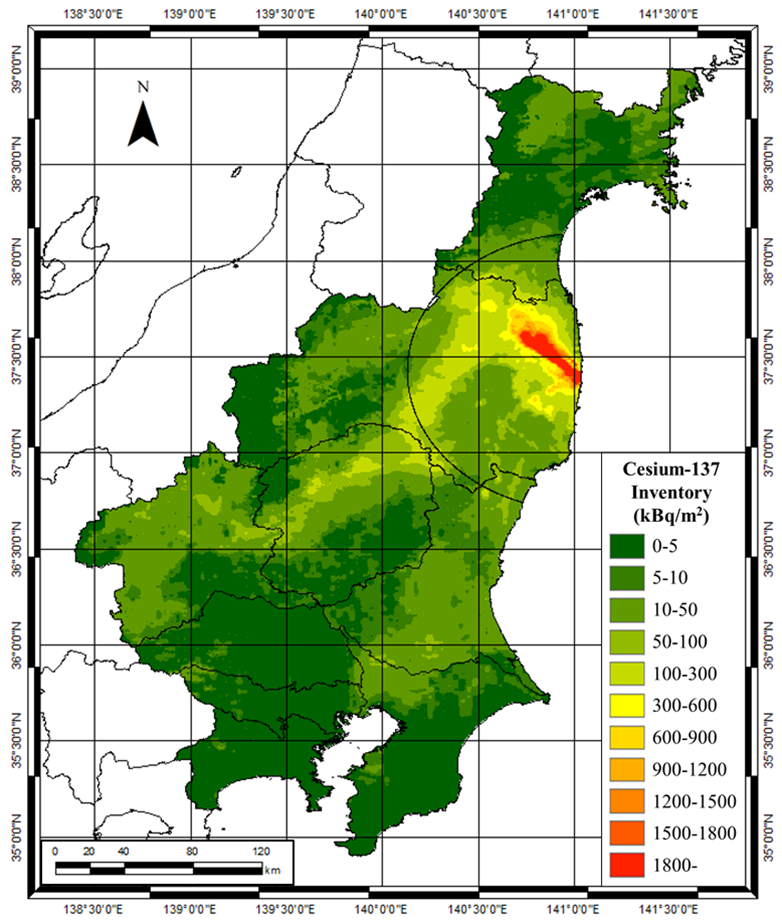 Dataset B | |
| Links | |
| Data Access: | http://www.ied.tsukuba.ac.jp/~fukushimafallout/ |
| DOI: | http://dx.doi.org/10.24575/0002.201805 |
| Citation & Contact Information | |
| How to Cite: | Publications based on data acquired via Center for Research in Isotopes and Environmental Dynamics (CRiED) access services should cite the CRiED in the standard format outlined here. Proper citation ensures that source information is available for use by future researchers. Researchers publishing analytical pieces using data obtained from the CRiED are encouraged to provide the Center with a copy of the work or its citation information for inclusion in the “Bibliography of publications using data from the CRiED”. Citations can be submitted by email at jimu”@”ied.tsukuba.ac.jp or by sending them to contact listed below. |
| Contact: | Hiroaki Kato (ORCID ID: 0000-0003-0194-3775)/ e-mail: kato.hiroaki.ka@u.tsukuba.ac.jp Wenchao MA (ORCID ID: 0000-0003-1470-8483)/ e-mail: wma@ied.tsukuba.ac.jp Naomi Nakajima/ e-mail: nakajima@ied.tsukuba.ac.jp |
| Citation: | Center for Research in Isotopes and Environmental Dynamics at University of Tsukuba, Database Web site: http://www.ied.tsukuba.ac.jp/en/database/. Note: Available from, rather than Retrieved from, indicates that the URL takes you to a download site, rather than directly to the data set file itself. Dataset A: In addition to the above mentioned citation, the following article should be referred in researchers publishing analytical pieces. Kato, H., Onda, Y. (2018) Determining the initial Fukushima reactor accident-derived cesium-137 fallout in forested areas of municipalities in Fukushima Prefecture. Journal of Forest Research 23(2), 73-84. DOI: 10.1080/13416979.2018.1448566 Dataset B: Kato, H., Onda, Y., Gao, Xiang, Sanada, Y., Saito, K. Reconstruction of a Fukushima accident-derived radiocesium fallout map for environmental transfer studies. Journal of Environmental Radioactivity, Submitted. |
| Acknowledgements: | The survey results reported here were provided by the Center for Research in Isotopes and Environmental Dynamics, University of Tsukuba. |
| Provider Version | |
| Ver. 1.0 Dataset A: -Data description (3 KB) -CSV file format (17 MB) -ESRI Shape file format (4.8 MB) Dataset B: -Data description (3 KB) -CSV file format (69 MB) -ESRI Shape file format (19 MB) | |
| Update History | |
| Maintenance: | 2018/03/23 Dataset A, English web site is released. 2018/03/30 Dataset A, Japanese web site is released. 2018/04/18 Dataset B web site is released. 2018/05/11 DOI is granted. 2018/07/04 The citation is partly revised. |
| Description of Data | |
| Ver.1.0 | The data set contains the original point data of the reconstructed initial fallout map of the Fukushima accident-derived 137Cs in Fukushima Prefecture and neighboring prefectures. The data set consists of two databases, namely Dataset A which is initial 137Cs fallout map within Fukushima Prefecture, and Dataset B which is the initial fallout map covering wider areas of prefectures of Fukushima, Miyagi, Tochigi, Gunma, Ibaraki, Chiba, Saitama, Kanagawa and Tokyo. The original data of Dataset A was published in Journal of Forest Research (Kato and Onda, 2018). |
- Link to Dataset AInitial Cs-137 deposition datawithin Fukushima Prefecture
- Link to Dataset BInitial Cs-137 deposition datain eastern part of Japan
日本語ページへ