Welcome to ERAN Database
| Title | Vertical water quality profile at seven observation points in Tsukumo Bay, 2021 | |
|---|---|---|
| Author 1 | Shouzo Ogiso | |
| Author 2 | Toshio Sekiguchi | |
| Author 3 | Yoichiro Kitani | |
| Author 4 | Nobuo Suzuki | |
| Authors 5- | ||
| Subject | Oceans | |
| Subject_sub1 | ||
| Subject_sub2 | ||
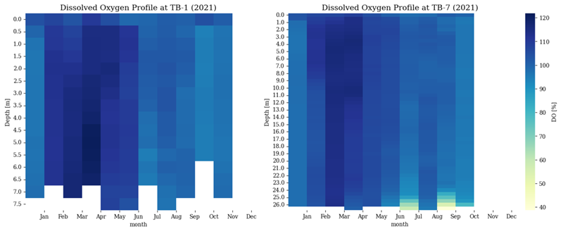
| Abstract | This dataset contains 2778 vertical profiles of water quality in Tsukumo Bay, Japan, collected in 2021, no data are available for December. The data were collected using a JFE Advantech AAQ-RINKO175 direct-reading water quality meter at seven fixed stations at northwest of Hourai Island. Measurements were taken monthly from the surface to the bottom, recording depth, Seawater Temperature [℃], Salinity, Conductivity [mS/cm], EC25 [μS/cm], Density [kg/m3], σT, Chl-Flu. [ppb], Chl-a [μg/l], Turbidity [FTU], DO [%], DO [mg/l] and Photon [μmol/(m2*s)]. The raw data were processed using JFE Advantech's AAQ-RINKO data processing software to generate vertical profiles. The dataset includes only the data collected during the descent from the surface to the seabed, with the turbidity data used to determine the time of bottom contact and exclude data points immediately before touchdown. Data processing was performed at 0.5 m intervals with a layer thickness of ±0.1 m. Data collection is still ongoing, with continued measurements planned for the future. | |
| Temporal coverage | 2021 | |
| Spatial coverage | 37.3059 N ~ 37.311117 N, 137.231267 E ~ 137.236333 E | |
| File format | Delimited | |
| Language | English | |
| Discovery metadata record | ||
| Publisher | Center for Research in Radiation, Isotopes, and Earth System Sciences, University of Tsukuba | |
| Publication year | 2025 | |
| Publication date | 6th of June | |
| Digital Object Identifier (DOI) | 10.34355/Ki-net.KANAZAWA-U.00274 Data Download (108KB) | |
| Short DOI | ||
| Citation text | Ogiso, S., Sekiguchi, T., Kitani, Y., & Suzuki, N. (2025). Vertical water quality profile at seven observation points in Tsukumo Bay, 2021 [Dataset]. Center for Research in Radiation, Isotopes, and Earth System Sciences, University of Tsukuba. https://doi.org/10.34355/Ki-net.KANAZAWA-U.00274 | |
| Serial at center | 00274 | |
| Serial at each Univ./Institute | KANA0033 | |
| Key word 1 | Water quality | |
| Key word 2 | Vertical profile | |
| Key word 3 | Coastal monitoring | |
| Key word 4 | Time series | |
| Key word 5 | Noto Peninsula | |
| Remarks | The geolocations and water depths of the seven observation points are as follows: TB-1: 37.311117°N, 137.231267°E, depth 7.3 m TB-2: 37.310217°N, 137.231650°E, depth 8.5 m TB-3: 37.309200°N, 137.232067°E, depth 16.8 m TB-4: 37.308733°N, 137.232483°E, depth 19.1 m TB-5: 37.307717°N, 137.233583°E, depth 22.3 m TB-6: 37.306933°N, 137.234883°E, depth 23.8 m TB-7: 37.305900°N, 137.236333°E, depth 26.0 m | |